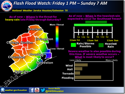
An area of heavy rainfall is expected to develop to the west of the region Friday afternoon then spread eastward through the region Friday night and Saturday morning. Where the heaviest rainfall sets up is still too early to pinpoint but this pattern is extremely conducive to heavy rainfall. Still some uncertainty as to the timing but confidence is increasing for the heavy rainfall threat
In addition to heavy rain and flooding – the possibility of severe weather in the form of damaging winds and hail will develop Friday night and early Saturday. After the last event we saw how wind gusts in excess of 40 mph and the soggy soils were enough to bring down trees.
The threat of intense rainfall rates early Saturday should gradually diminish Saturday afternoon and evening but heavy rainfall may still occur if storms track over hard hit areas into Sunday morning.
Sunday afternoon drier weather should be on tap although a frontal boundary should stall near the coast or just offshore. Rainfall may return Monday and Tuesday focused along the boundary with arrival of the next weather system.


