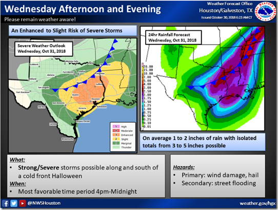
A cold front moving into the area will bring a threat of widespread showers and thunderstorms on Wednesday. The front should move into Southeast Texas late Wednesday afternoon near the College Station area then move southeast through the Houston area Halloween night and off the coast early Thursday morning.
Strong to severe storms will be possible especially for areas northeast of a College Station to Conroe to Liberty line. Elsewhere strong thunderstorms will be on tap. At this point it appear the main threats will strong damaging winds and heavy rainfall. The Storm Prediction Center has elevated most of Southeast Texas in enhanced risk for severe weather.
Rainfall totals of 1-2″ common and isolated amounts of 3-5″. Street flooding possible.
Thursday cooler with gusty northwest winds and drying out.
Marine Interests:
Southerly flow of 10 to 20 knots through early Thursday morning. Severe storms possible near the cold front early Thursday. Wind gusts in excess of 35 knots likely.
After the frontal passage northwest to north winds near 20 knots with seas building to 6-9 feet.
______________________________________________________________________
NWS Houston will be utilizing the following urban flash flood messaging for this event:
– Drive with caution. Car may flood in low-lying areas. Ponding on roadways may increase risk of hydroplaning.
– Pay attention to the weather. Monitor the NWS, your local media, HCFCD and other official weather information sources.
– Rain may move repeatedly across the same area, causing a rapid rise on creeks and bayous. However, creeks and bayous are not likely to exceed their banks.


